DX-Sky
Overcome limitation of RF based 1:1 drone control with multi-drone management technology.
Why Multi-drone management is essential?
Today, most organizations are using drones to capture high-precision imagery or diagnose areas that are difficult for humans to access.
While most essential missions are well defined, 1:1 drone control via RF has limitations in responding to emergencies such as collisions with terrain or objects, crashes, and disappearances due to loss of communication. Repeating the same task with a single drone makes it difficult to respond quickly. And capturing images to SD cards and manually managing files increases processing time.
SyncTechno DX-Sky offers an innovative way to resolve these problems, with patented multi-drone control technology.
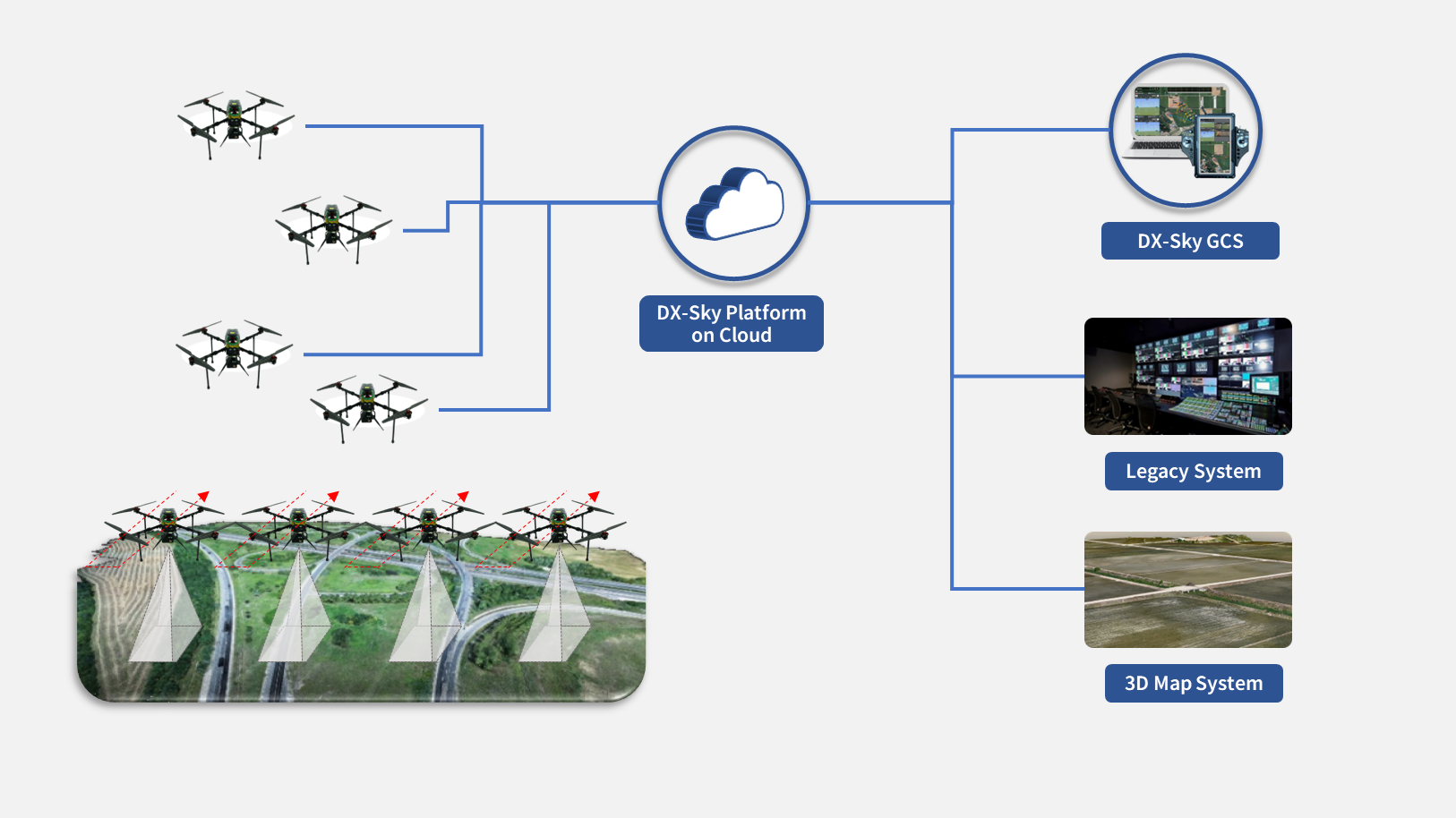
Upgrade existing 1:1 RF communication to LTE communication
Enable LTE/5G connectivity with communication boards and modules to operate and manage multiple drones from a single control room.

Remote control and real time data collection to existing infrastructure
Anytime, anywhere, easily collect data and connect to business systems only with wireless communication.
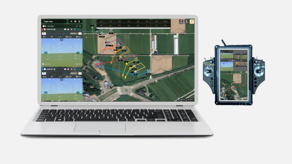
Monitor and control in any device, regardless of the device type
Real-time monitoring from any device, including PCs, tablets, and smartphones. Remotely monitor drone operations in real time and manage issues.
DX-Sky Family
The DX-Sky GCS Application is an installable application that provides unified user experience. It is provided to customers pre-loaded on the controller of the drone hardware manufacturer and provides the ability to communicate directly with the drone via RF channel in case of poor internet access in the flight area. Pre-loaded into the drone's controller, it provides 1:1 RF communication in areas with poor internet access.
DX-Sky GCS Application provides general drone operation core functions such as flight planning, control and management. At the same time, it also includes the capability to design and assign collaborative missions with multiple drones over a wide area. In particular, the offline mode allows for missions such as map data caching, direct RF communications in areas with poor internet service.
Features and core capability
- Automatically generate efficient flight paths for assigned area
- Automatically generate total flight distance, estimated flight time, video recording cycle and interval
- Applies IoT international standard oneM2M technology
- Select between satellite map and normal map depending on the drone operating environment
- Check images captured on missions in real time
- Export and import capabilities for frequently used route
DX-Sky GCS platform is a cloud-based drone operations system that provides a single, unified control environment for controlling multiple drones in an internet-connected environment. Only authorized users can register, manage, and operate drones.
In addition to common drone operation functions such as flight planning, control and management, DX-Sky GCS Platform includes the capability to operate multiple drones simultaneously over a wide area to design and assign collaborative missions. Data collected by drones can be synergized with the DX-Sky Mission Adapter framework to create new value through the combination of flight and mission data.
Features and core capability
- Manage Drone Devices and Users
- Display airspace and weather condition
- Automatically create flight path for video recording
- Automatically generate total flight distance, estimated flight time, video recording cycle and interval
- Select between satellite map and normal map depending on the drone operating environment
- Check images captured on missions in real time
- Export and import capabilities for frequently used route
- Applies IoT international standard oneM2M technology
DX-Sky Mission Adapter Framework is a cloud-based system that supports drone mission data integration. By uploading mission data collected from multiple internet-connected drones to a cloud environment, you can integrate with existing systems.
The DX-Sky Mission Adapter Framework can be customized to enable secure flight and mission data exchange within customer’s existing security framework and interfaces. And it also provides data visualization capabilities for mission data verification, allowing to visualize video recording coverage with a dedicated user UI for data verification.
Features and core capability
- Manage mission lists and validate locations
- Select and download missions
- Check mission image
- Zoom in and out of the acquired maps
- Check for image duplicates
Case Study

Korea Land and Geospatial Informatix Corporation
For digitalization of paper cadastral maps, the Korea Land Informatix Corporation applied real-time drone remote control technology and simultaneous operation of multiple unmanned aerial vehicles.
Why not now? We can go anywhere.
- Are your drones sitting idle and wasting money?
- Want to innovate your business with drones?
- Want to know how drones are changing the business in your industry?
- Do you have a lot of urgent tasks to complete in a short amount of time?