
DX-Ocean

DX-Ocean collects and analyzes the status and quality of LTE/5G mobile and VSAT satellite links and manages them together with voyage data.

Integrated management of link quality as conditions at sea change

Mobile networks play a larger role in coastal waters and satellite links further offshore, and communication quality also varies with weather, route and vessel position.
DX-Ocean collects the status of every communication channel in one place and builds up a quality history, providing a basis for analyzing and validating path selection policies.
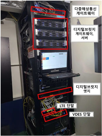
Multi-network maritime gateway (top) installed in the equipment rack of the KASS autonomous test ship (labels in Korean)
※ Equipment rack on the test ship (labels in Korean show each device)
Installed on a test ship

Long-route trial between Korea, China, Vietnam and Thailand

In the Korea Autonomous Surface Ship (KASS) project of the Ministry of Oceans and Fisheries and KIMST, the DX-Ocean multi-network maritime gateway was installed on the autonomous test ship. On the long route sailed by the autonomous test ship between Korea (Incheon and Busan), China (Shanghai), Vietnam and Thailand (July 2024 to December 2025), it ran commercial mobile and VSAT satellite networks together, proving its performance on a real route across coastal and open waters.

Rack layout (top to bottom)
  1. Multi-network maritime gateway
  2. Digital bridge gateway and servers
  3. Digital bridge edge
  4. LTE and other communication terminals
View the case study

A single gateway for different networks

The Multi-RAT multi-network maritime gateway collects the status of each link, including LTE/5G and VSAT, and serves as the hub that connects onboard systems with shore systems. Beyond simply linking different networks, it accumulates per-link quality data to support decisions on path selection and communication policies.

  • Integrated status collection for multiple channels including LTE/5G and VSAT
  • Quality history by voyage segment, stored together with vessel position and voyage information
  • Data integration that connects onboard systems, the digital bridge and shore systems
  • Interworking tests with a commercial VSAT terminal (iDirect X7) and a test report from an accredited laboratory
  • Foundation for path selection and traffic policies that reflect service characteristics and link status
DX-Ocean concept diagram: the status of communication channels such as RAT 1 (e.g. LTE/5G), RAT 2 (e.g. VSAT) and RAT 3 (e.g. Starlink) is collected, retained and synchronized by the onboard gateway and passed on to operations and analysis

Continuous data flow even when connectivity at sea is unstable

Communication status and voyage information collected on board are first preserved on the vessel and synchronized again once the central connection is restored. The system is configured so that communication status and data history can be reviewed through the same operating workflow regardless of equipment differences.

  1. CollectLTE and VSAT status collected together with voyage information
  2. PreserveField data retained on board during connection outages
  3. SynchronizeStored data resent to and synchronized with the central system after the link is restored, minimizing data loss
  4. AnalyzePer-segment quality reviewed together with service requirements

A terminal that measures LTE/5G link quality at sea

The maritime broadband terminal continuously checks the connection status and signal quality of the LTE modem and reports them to the gateway.
It structures key indicators such as RSRP, RSRQ, RSSI and SINR, together with serving cell and network information, into data that can be used to assess and analyze communication quality.

It supports network configuration so that onboard equipment can use the LTE link as an external communication path, and it provides status information in a form other systems can use, allowing integration with the gateway and management functions.
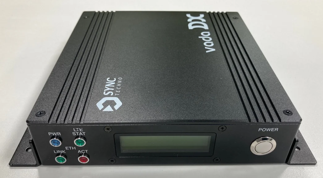
  • Collection of LTE connection status, network and base station information, and key quality indicators including RSRP, RSRQ, RSSI and SINR
  • Communication status delivered as shareable status data for integration with the gateway and external systems
  • LTE external network connectivity for the onboard network
  • Operation and recovery logic that continuously monitors connection faults and helps identify their causes
Exterior of the maritime broadband terminal prototype
Maritime broadband terminal prototype

Key specifications (upgraded prototype)

Processor
6-core CPU, 8 GB RAM, 64 GB storage
Cellular module
Quectel RM500Q-GL
Antenna
0.6–6 GHz wideband dipole (3–7 dBi), MIMO, N-type connectors
Size and casing
180 × 258 × 44 mm (1U rack mount), aluminum case
Measured throughput
210–380 Mbps (Incheon New Port, 11 August 2025)

Maritime link quality confirmed with real voyage data

These are research results from LTE and VSAT quality data actually measured over 12 voyages of a container ship, analyzed by time and voyage segment. They reveal coverage gaps, degradation patterns and link characteristics, and are used to validate path selection policies and switchover criteria.

Measured routes

12 container-ship voyages

Measured for nine months on routes between Incheon, Busan, Shanghai, Ho Chi Minh and Laem Chabang
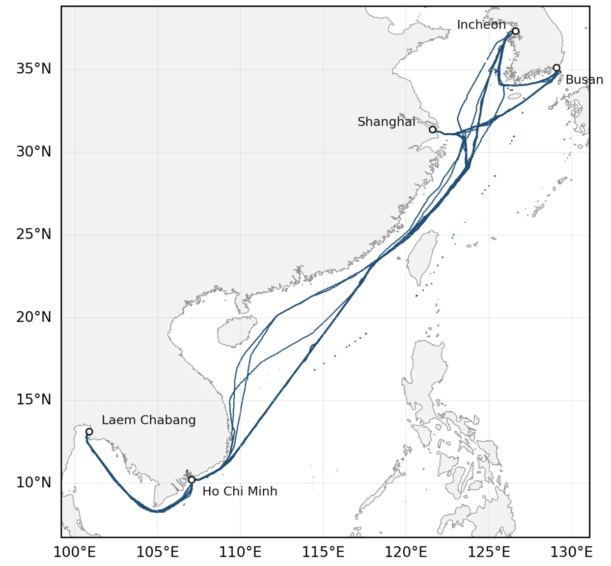
Map of the actual tracks of 12 container-ship voyages between Korea and Southeast Asia
Tracks of the 12 measured container-ship voyages (Incheon, Busan, Shanghai, Ho Chi Minh, Laem Chabang)Source: Koo et al. (2026), Applied Sciences
Measurement setup

Shipboard communication setup

Cellular and satellite terminals were connected to the multi-network gateway to log both links together
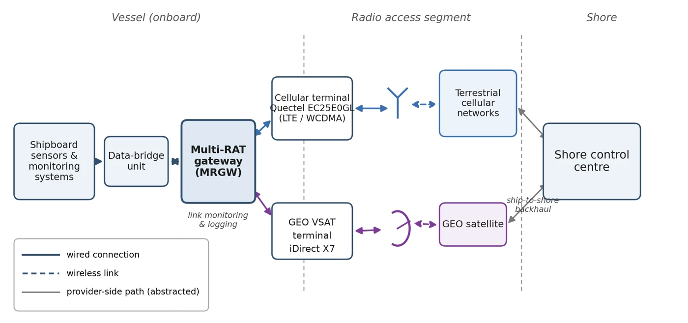
Diagram of shipboard sensors, cellular and satellite terminals connected through a multi-RAT gateway to a shore control centre
Shipboard communication setup used for the measurements (cellular and satellite terminals connected to the multi-RAT gateway)Source: Koo et al. (2026), Applied Sciences
Cellular · LTE/WCDMA

Received signal quality by voyage leg

Records meeting the received-power criterion ranged from 77.1% (Incheon → Busan) to 17.3% (Shanghai → Ho Chi Minh), about a 4.5-fold gap

  • Meets criterion
  • Attached, below criterion
  • No service
Voyage legMeets criterion
  1. Incheon → Busan77.1%
    Below criterion 22.8% No service 0.1%
  2. Busan → Shanghai40.9%
    Below criterion 46.4% No service 12.7%
  3. Shanghai → Ho Chi Minh17.3%
    Below criterion 38.9% No service 43.8%
  4. Ho Chi Minh → Laem Chabang30.9%
    Below criterion 50.3% No service 18.8%
  5. Laem Chabang → Ho Chi Minh25.0%
    Below criterion 59.9% No service 15.1%
  6. Ho Chi Minh → Incheon21.5%
    Below criterion 41.4% No service 37.1%

Criterion: LTE RSRP ≥ −100 dBm or WCDMA RSCP ≥ −85 dBm. Based on 470,920 valid cellular-state records while sailing.

Cellular (LTE/WCDMA) reception state by voyage legSource: Koo et al. (2026), Applied Sciences
Satellite · GEO VSAT

VSAT signal quality (SNR) and the effect of the threshold

26.5% of responsive records fell between 6 and 7 dB, so raising the threshold from 6 to 7 dB increased the store-and-forward share from 6.7% to 25.7%

SNR of responsive VSAT records
  • Below 6 dB 8.7%
  • 6–7 dB 26.5%
  • 7 dB and above 64.8%
Link allocation by SNR threshold (retrospective)
  • Cellular
  • VSAT
  • Store-and-forward

Cellular assignment stays at 28.8% at every threshold

SNR thresholdStore-and-forward
  1. No thresholdVSAT 70.6%0.6%
  2. 5 dBVSAT 69.0%2.2%
  3. 6 dBVSAT 64.5%6.7%
  4. 7 dBVSAT 45.4%25.7%
  5. 10 dBVSAT 31.0%40.1%

Records go to cellular when it meets the received-power criterion, otherwise to VSAT when it responds with SNR at or above the threshold, and otherwise to store-and-forward. Retrospective analysis of 319,363 joint-analysis records; no live traffic was redirected.

VSAT SNR distribution and link allocation by SNR thresholdSource: Koo et al. (2026), Applied Sciences

※ The map and setup diagram above are taken from the reference at the bottom of the page, and the two charts adapt results from the same paper

Next step under research

Path selection based on both link quality and transmission purpose

Maritime communications cannot be judged by connectivity alone. At any given moment, each network differs in latency, loss and available capacity, and the data to be transmitted differs in importance. DX-Ocean is researching and validating quality-of-service-based path selection that takes both link quality and service requirements into account.

Link qualityLatency, loss and available capacity assessed togetherEach network's quality is compared across several indicators rather than a single figure.
Service priorityReflects the importance of data and the quality it requiresWe are researching ways to vary path selection criteria according to data importance and performance requirements.
Stable switchoverStabilization conditions that reduce unnecessary switchingWe are validating switchover criteria that remain stable even when link status fluctuates around threshold values.

Implemented functions versus research scope

Communication status collection, history management, onboard preservation and synchronization are implemented. Path selection that considers latency, loss, available capacity and service importance is a technology under research and validation and is not presented as a completed commercial automatic switchover function.

References

Koo, H., Ryoo, C., & Song, J. (2026). Repeated-voyage measurement of cellular–GEO satellite complementarity and buffering implications for maritime IoT backhaul. Applied Sciences, 16(18), 9361. https://doi.org/10.3390/app16189361 (CC BY 4.0)